


Background
Rocky Mount, North Carolina faces significant development pressure as a result of several economic factors. Housing demand exceeds supply, particularly at a price point affordable to the middle class. City officials identified an updated development code and related ordinances as one (of many) solutions for addressing its housing affordability pressures, especially in existing neighborhoods.
Problem
The rapid pace of growth and increasing pressures on housing affordability has strained the limits of Rocky Mount’s existing land development regulations. Advanced GIS analytical tools were necessary for analyzing and communicating how a potential code change or new development impacts neighborhoods. Rocky Mount needed both a technical and communication solution that enabled better analysis and storytelling.
Technical Analysis
It is difficult to evaluate a development code until it has been in effect for decades. Rocky Mount has development pressure now and cannot wait decades to evaluate whether its proposed solution achieved its objective. They needed a digital analytical tool that could predict outcomes for various code changes and analyze existing codes.
Communication and Storytelling
Development pressure can expose division amongst neighbors. Misinformation or a lack of understanding about the impact of a code change can doom Rocky Mount’s potential solution. Effectively communicating the code changes and their impact, though, is challenging. Too often, paper-based, two-dimensional site plans are used to demonstrate a potential development.
Solutions
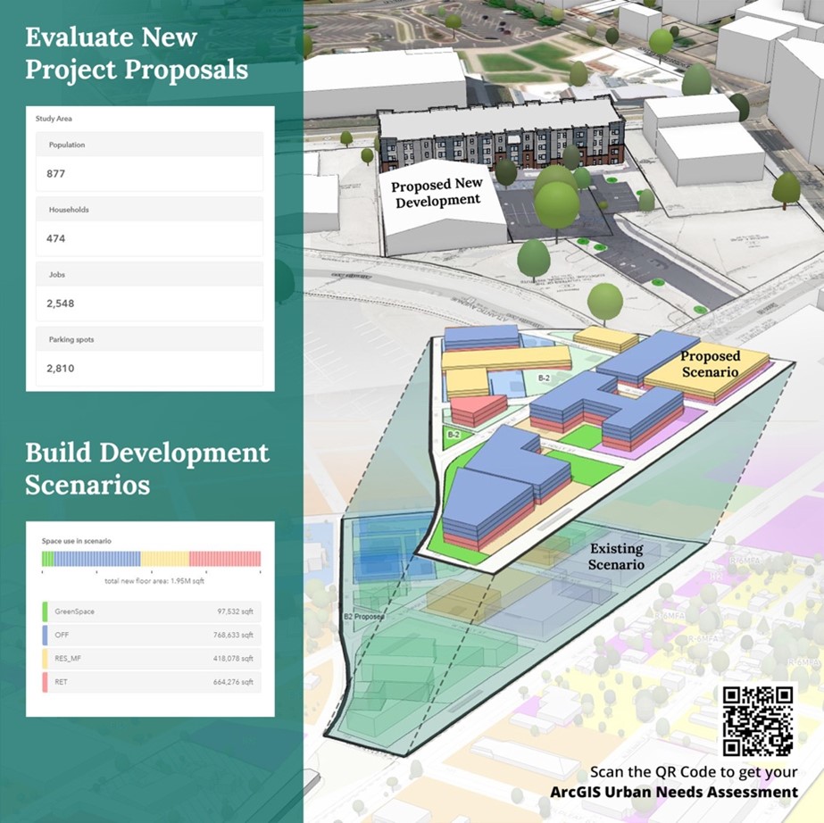
Rocky Mount identified ViewPro’s proprietary technology as its technical and communication solution. To begin, officials filled out ViewPro’s needs assessment to identify specific problems ArcGIS Urban can help solve. The next step was to produce an ArcGIS Urban model. This required converting traditional 2D data, such as land-use designations, floor-to-area ratios, and building heights into 3D data. Staff at ViewPro incorporated other Esri software, including ArcGIS Pro, CityEngine, and 3D Analyst to achieve the desired model.
To maintain efficient infrastructure networks, city officials want more infill development. Rocky Mount’s new tool simulates code changes, demonstrating how a zoning variance to reduce a building’s setback and floor-area ratio will affect a proposed development project and neighboring parcels. An uproar from residents against a new development – no matter how much it can address Rocky Mount’s housing affordability problem – will doom a project.
Thanks to their new ArcGIS Urban model, Rocky Mount officials can now demonstrate – through high quality visualizations – how a proposed building, like an apartment building, fits within the surrounding neighborhood. It is now possible to see how increased densities impact an existing neighborhood full of single-family homes. This accuracy of predictive analytics leads to a more informed discussion and decision-making process.
Summary
Technology evolves rapidly, and Rocky Mount is now equipped to use analytical and communication tools to effectively address the growing city’s housing affordability problems. Rocky Mount can identify, analyze, and communicate future changes to the city’s development code. First and foremost, the city’s new tools can identify the relevant code language that leads to an increase of affordably priced homes in areas with existing infrastructure. These efforts are building toward development of a full-scale digital twin of Rocky Mount, which will allow officials to use more 3D data analytics for decision-making.